
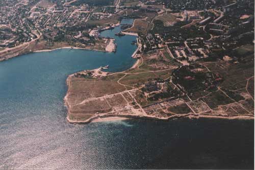
 The site of Chersonesos is an
exposition of excavated buildings and structures dating to different periods
of the city's life: Hellenistic, Roman, and especially Byzantine. It covers
a large area (45 ha) and provides an exhaustive representation of the city's
regular plan (the so-called Hippodamean system), which changed only slightly
in the two-thousand-year history of Chersonesos. Although the site of Chersonesos
is located along a picturesque seashore within the city limits of Sevastopol,
it is set apart from the modern city. For these reasons it is one of the
most popular tourist attractions in Ukraine today. Every year leading Ukrainian
and foreign scholarly institutions conduct scientific research at the site.
The site of Chersonesos is an
exposition of excavated buildings and structures dating to different periods
of the city's life: Hellenistic, Roman, and especially Byzantine. It covers
a large area (45 ha) and provides an exhaustive representation of the city's
regular plan (the so-called Hippodamean system), which changed only slightly
in the two-thousand-year history of Chersonesos. Although the site of Chersonesos
is located along a picturesque seashore within the city limits of Sevastopol,
it is set apart from the modern city. For these reasons it is one of the
most popular tourist attractions in Ukraine today. Every year leading Ukrainian
and foreign scholarly institutions conduct scientific research at the site.
In the earliest period of its existence, Chersonesos occupied an insignificant part of the Heraklean Peninsula, initially only the territory of the western shore of Quarantine Bay. Later, the city borders were widened more than once, the total area growing almost twofold, and by the beginning of the 1st century AD they reached the eastern shore of Sandy Bay.
The ancient city is, first and foremost, a fortress with a formidable line of defense aligned with the topography of the territory and intended to withstand long sieges and assaults by hostile armies. The early, relatively small settlement on Quarantine Bay was surrounded by a short wall which was fortified in the late 4th - early 3rd centuries BC. Subsequently, the total length of the defensive walls of Chersonesos reached approximately 3.5 kilometers in length, 3.5 - 4 meters in width, 8 - 10 meters in height, with towers stretching 10 - 12 meters high. Eventually the entire area of the city, covering about 30 hectares, was protected on all sides by defensive walls.
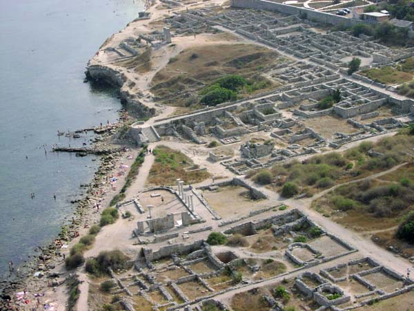
As in every city, the limits of which were determined by defensive walls, Chersonesos had narrow streets and small squares which were located as a rule in the busiest districts. The regular plan of perpendicular streets carved blocks into approximately equal areas. In the ancient period each block consisted of 2 - 4 residential houses. In the medieval period some blocks were combined and buildings were made more compact because the number and width of streets were decreased. Although several blocks and entire districts changed appearance, the regular system of urban planning inherited from the ancient period was preserved.
Necropoleis (cemeteries) were located outside the city walls and along roads. In the ancient period the deceased were buried in graves or vaults; this ritual was preserved even after the conversion of the population to Christianity. A monument (stela) was usually placed at the grave, which initially indicated the deceased's name, and later his/her age as well. Burials within the city took place only from the 10th - 14th centuries, and as a rule only inside or near churches and chapels.
Craftsmen's workshops and residential quarters were located outside the city near the defensive walls, and agricultural plots of land were situated very close to these populated districts.
Wars, fires, changes in population and religion all left their mark on the appearance of the city, which is why the architectural portrait of Chersonesos changed more than once during its two thousand-year history. Dilapidated or burnt buildings were taken down and new structures were erected in their place. During construction the remains of earlier buildings were usually covered with debris or were incorporated into the new foundations. All the buildings relating to pagan cults were demolished in this way in the early Middle Ages after the advent of Christianity.
Constant raids by nomadic tribes in the 12th - 14th centuries undermined the economy of Chersonesos. As a result of a Mongol-Tatar raid in the late 14th century the city was destroyed. For a long time after this event Chersonesos was a site of ashes: burnt-down houses, churches and fortifications. In the course of time Chersonesos became overgrown with grass and shrubbery and was used as a source of building materials. This was the state of Chersonesos when initial excavations were begun in the late 1820s.